
Archive Record
Images
Metadata
Title |
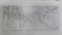
Map of Lewis and Clark's Track Acrofs the Western Portion of North America from the Mississippi to the Pacific Ocean…1804, 5, and 6 (Oregon Historical Society Reprint) |
Object Name |
Chart, Navigational |
Catalog Number |
PS2025.4.268 |
Date |
1814 |
Scope & Content |
Map of Lewis and Clark's Track Acrofs the Western Portion of North America from the Mississippi to the Pacific Ocean…1804, 5, and 6 (Oregon Historical Society Reprint) by Samuel Lewis. |
Collection |
Captain John Baldry Collection |
Pub Date |
1814 |
Publisher |
Lewis |