
Archive Record
Images
Metadata
Title |
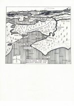
Seattle Harbor, Puget Sound, Washington Territory, 1879 |
Object Name |
Map |
Catalog Number |
PS2016.9.68 |
Scope & Content |
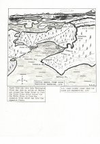
Two versions of a hand-drawn map, done by Matson for his Black River article in Sea Chest (see PS2016.9.64), based on US Coast Survey Chart for names and perspective. First copy is the original titled "Seattle Harbor, Puget Sound, Washington Territory, 1879" and has typed name labels glued around the map, which shows Battery Point, the Duwamish River, Seattle/Elliott Bay, Lake Washington, and the Cascades. Second copy is a more polished copy with more a extensive label explaining the river flows. |
Creator |
Bob Matson |
Other Creators |
USCGS |
Collection |
Robert E. Matson |
People |
Bob Matson |
Search Terms |
Elliott Bay Duwamish River Port of Seattle Black River Cedar River White River |