
Archive Record
Images
Metadata
Object Name |
Map |
Catalog Number |
PS2016.9.67 |
Scope & Content |
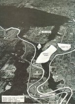
One black and white aerial view photograph (from Port of Seattle) of mouth of Duwamish and Elliott Bay with overlaid white lines from the US Coast Survey chart, 1879, showing original Duwamish, Edwards Island, Island No. 1, No. 2 (unlabeled) and No. 3, traced by Matson. |
Creator |
Bob Matson |
Other Creators |
Port of Seattle USCGS |
Collection |
Robert E. Matson |
People |
Bob Matson |
Search Terms |
Elliott Bay Duwamish River Port of Seattle |